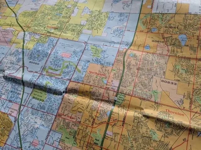
Part of a 1996 Rand McNally map of the Denver area, showing how different municipalities were shaded in different colors.
One thing I always appreciated about the old Rand McNally street maps was how each municipality was shaded in a different color with clear boundaries, making it easy to see where one stopped and another began. This allowed readers to know at a glance where city limits were, and understand which areas were incorporated into which cities, and which areas were unincorporated. The lack of municipality boundaries is one thing I miss about most modern digital maps.[1] I understand municipal boundaries are of little practical value for most people's daily lives.[2] Nonetheless, I think there are stories to be told by this data.
The area between Denver and Fort Collins is rapidly growing, with many formerly small towns booming and expanding their city limits in surprising ways. Likewise, many established suburbs are extending to areas far away from their traditional cores. The more I travel around this area, the more astonished I am by how some areas seem to be part of suburbs and towns that I never would have expected. I often find myself wishing for a map that clearly shows municipal boundaries so I can get a better idea of what is going on.
The municipal boundary map
Not wanting to wait for someone else to make such a map, I downloaded the Colorado OpenStreetMap data and proceeded to make some software to generate exactly the sort of map I'd like to see. The OpenStreetMap data set I used is from March 1, 2026. The contained boundary data is not very up-to-date — when I browse the various municipal GIS systems, I notice that many of these municipalities now have additional territory. So we're probably looking at boundaries that are a few years old. However, in spite of not being a current snapshot of boundaries in 2026, this data should be good enough to get an idea of what's happening.
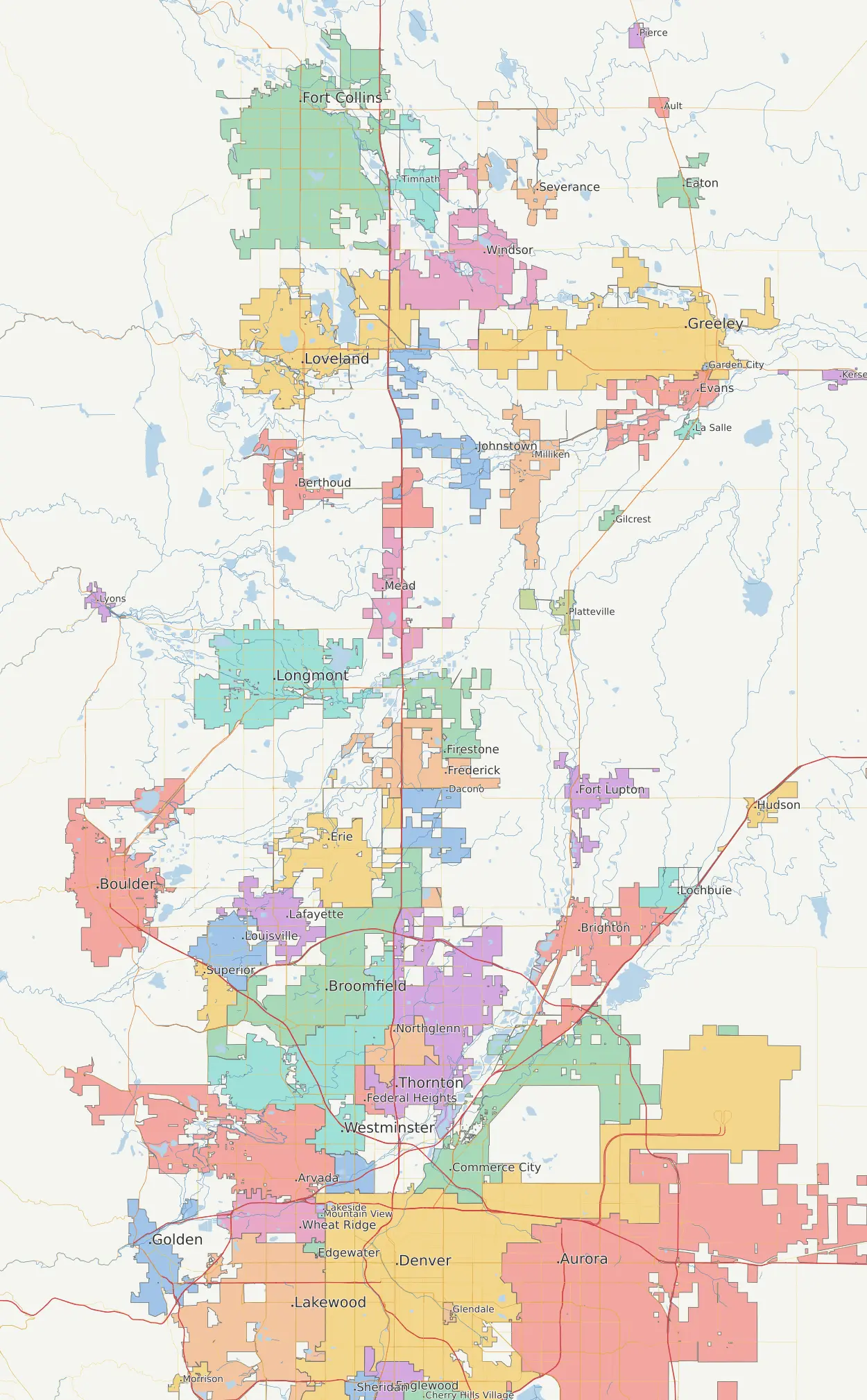
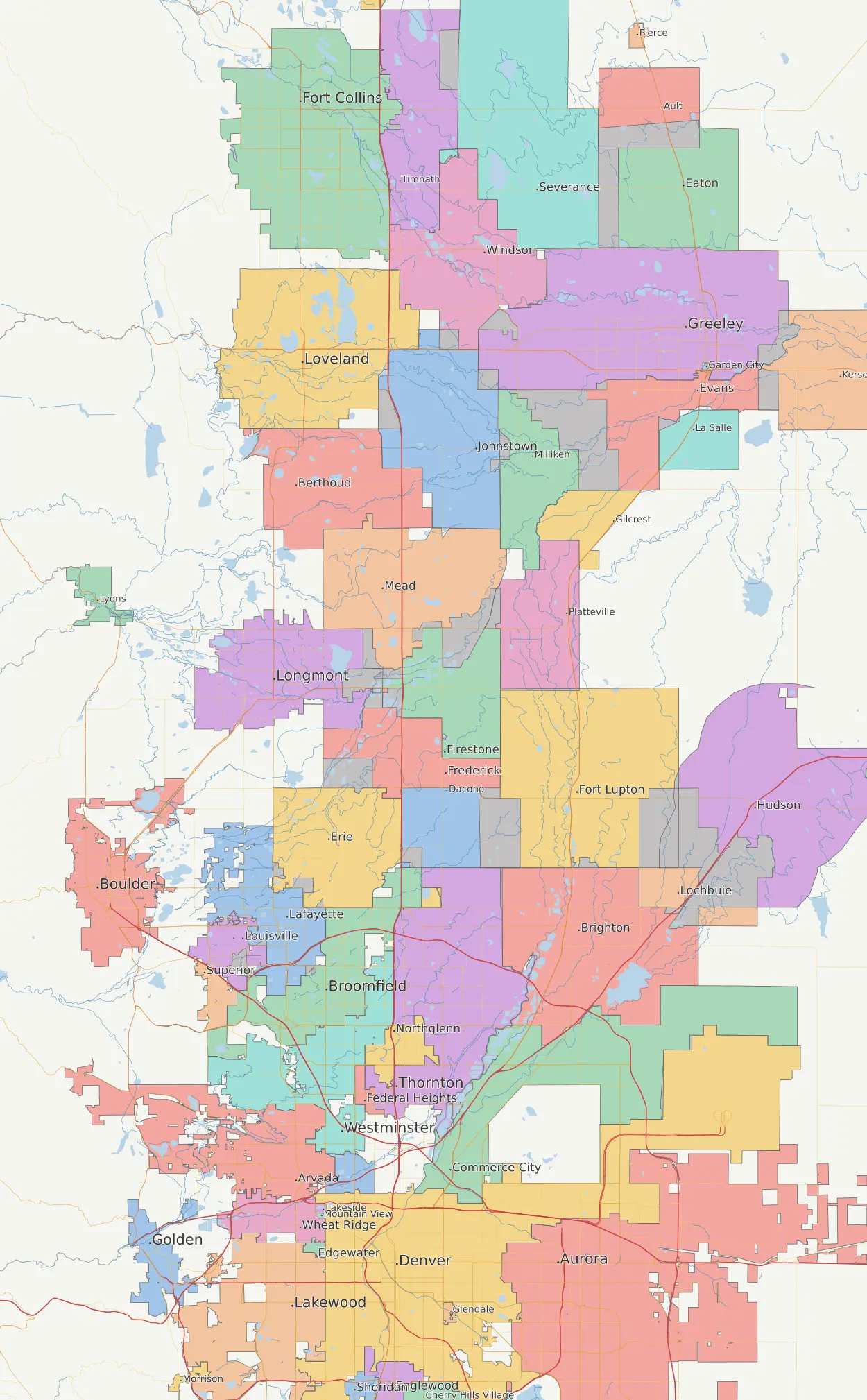
A rendering of municipal boundaries from Denver to Fort Collins based on data provided by OpenStreetMap.
I was not disappointed in the results. This map tells a lot of fascinating stories!
Opportunistic annexation for fun and profit
Before diving into the map details, let's take a moment to understand how municipal annexation works in Colorado.
Incentives rule the world. Municipalities are highly incentivized to annex areas that will bring them the most tax revenue (e.g. present or future commercial/retail areas with high sales tax potential, especially near major highways) and avoid annexing areas that may bring unwanted expenses (e.g. residential areas where they may be obligated to provide municipal services). Left to their own devices, they would selectively annex only the juiciest parcels they could find, even if many miles away.[3]
Given the potential for abuse, states impose rules such as contiguity requirements on municipalities intended to curb such opportunistic annexations. In turn, municipalities attempt to find loopholes around the rules by engaging in practices such as flagpole annexation — annexing narrow parcels of land, often just the width of a highway, in order to annex distant parcels while being technically contiguous.
Colorado's annexation laws are based on the Municipal Annexation Act of 1965 (C.R.S. § 31-12-101, et seq.) which has been amended many times over the years. For the purposes of interpreting the map, the key requirements are:
- The one-sixth contiguity rule (§31-12-104(1)(a)). An annexation must have at least one-sixth of its perimeter contiguous with the existing boundary. However, the perimeter contiguity requirement can often be overcome with geometrical and legal cleverness, and the rule further allows a series of parcels to be annexed as a group for the purposes of establishing contiguity, so this rule isn't as effective as it might appear at first glance.
- The three-mile rule (§31-12-105(1)(e)). No annexation can extend a municipal boundary more than three miles in any direction in a single year. This is critical for understanding many annexations. By strategic use of flagpole annexations, the potential expansion area can be greatly increased with a minimal investment, maximizing a municipality's options for further annexations.
- Enclave annexation (§31-12-106(1)). If a city completely surrounds a piece of unincorporated land, it may annex it without the usual hearing and petition process — but only if the surrounding territory is substantial and more than just a right-of-way such as a highway (to prevent use of flagpoling to annex land without the usual process).
- Competing municipal claims (§31-12-114). There is a process for resolving disputes between two municipalities that want the same territory, but it is highly weighted in favor of the municipality with more than two-thirds boundary contiguity. This adds an extra dimension to the game — municipalities must think strategically about arranging boundary contiguity for future land grabs before their rivals can do so.

The municipal annexation maneuvers to gain territory often seem like a game of Go.
The cleverness employed by municipalities to work around the rules creates bizarre, gerrymandered shapes where the city technically satisfies a contiguity requirement but clearly isn't engaging in orderly growth. Sometimes I wonder if municipalities feel more emboldened to make such opportunistic annexations because people seldom see these crazy boundaries on modern maps.
As municipalities grow toward each other, annexation becomes a competitive sport where municipalities are pressured to "call dibs" on land before someone else does. Annexations become a game of Go where each player tries to gain as much territory as they can, while also trying to block their opponent from gaining territory with strategic defensive annexations.[4] The result is piecemeal, bizarrely shaped franken-cities.
Observations
Let's take a look at a few interesting things on the map.
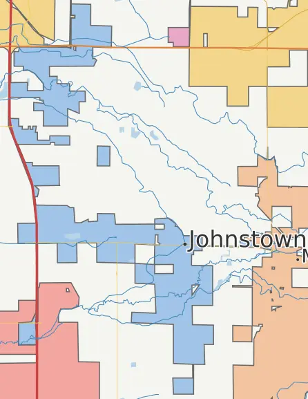
Johnstown may be the poster child of fragmented annexation. I regularly hear people express surprise about the places that are considered Johnstown. Shall we meet in Johnstown, or Johnstown, or Johnstown, or Johnstown? (Or the Buc-ee's?)
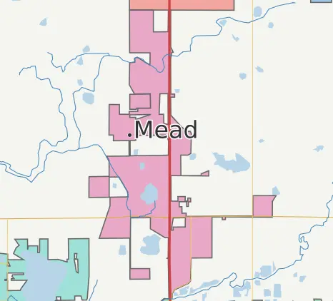
The folks in Mead sure love themselves some I-25. Everyone wants that sweet, sweet high value land adjacent to Coloradans' favorite highway. The land to the east and west of Mead... not so much.
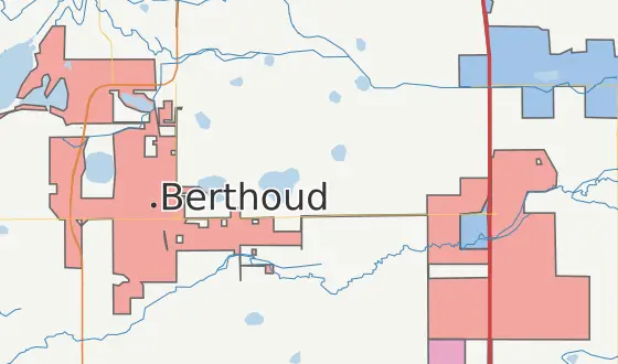
Small towns like Berthoud that settled along the old highway may enjoy some quaint charm, but miss out on the economic opportunities provided by the bustling freeway. But why settle? Thanks to flagpole annexation, you can truly have it all!
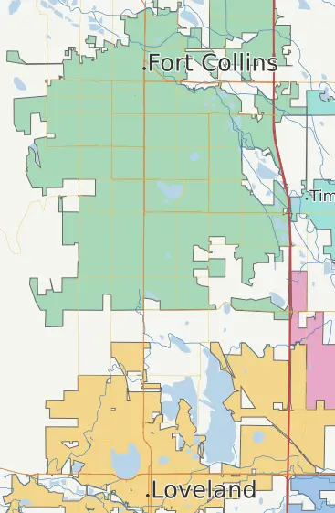
I was surprised to see this gap between Fort Collins and Loveland. It seems a bit unlikely given the immense growth in the area, and it looks just a little bit too regular. It turns out that this is an intentional "community separation" agreement meant to preserve the "physical and visual separation" between the two cities. From the looks of the rest of the map, I'm guessing this idea didn't really catch on elsewhere.
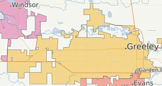
All the major Northern Colorado cities have an attraction to I-25. Greeley's original town site is now at the extreme eastern side of the city's current boundaries, as the city desperately tries to reach westward towards I-25. But wait, what's that to the west? In a bold power move, Windsor has leaped south with just enough annexation to block Greeley's expansion! (At least north of US-34.)
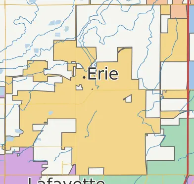
Erie, my fair town, is expected to expand throughout the remaining unincorporated land in this square of highways, according to its planning area boundary. But the planning area is largely an aspirational signaling of intent without any real legal teeth. So some of these adjacent municipalities could make a power move into the square, especially if Erie manages to upset a neighbor like Lafayette. (Again.)
Notice the flagpoled fence in the northeast part of the map. Someone at Erie is truly a master of Go, and understands that controlling a territory does not require occupying it, but rather merely surrounding it. Because the surrounding territory consists of flagpoles instead of substantial land, Colorado law does not permit a trivial "enclave annexation" of the interior which would skip the usual annexation process. Nonetheless, this annexation strategy is quite effective at protecting the enclave from invading rivals.
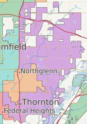
Thornton used to be firmly south of Northglenn. Apparently while Northglenn was sleeping, Thornton annexed all remaining unincorporated land around it, cutting Northglenn off from future expansion, and paving the way for Thornton's future territorial ambitions to the northeast.
But wait a second... what's that bit of land at the top of the map that's shaded the same color as Northglenn?
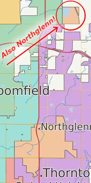
Surprisingly, Northglenn's city limits include a satellite exclave a full six miles north of what would otherwise be the city's northern boundary, in Weld County! This is Northglenn's "Section 36" area. How it was legally annexed is beyond me. It certainly wouldn't be legal with today's annexation laws. Perhaps the laws were different at the time, or it was somehow part of the original 1969 incorporation. Either way, this territory truly puts the "North" in "Northglenn"!
Northglenn operates a water treatment plant in this area, but I'm baffled at why they felt the need to include it in their political jurisdiction. After all, cities are free to own and operate infrastructure in other cities or unincorporated areas. In fact, Northglenn's utility GIS shows that they operate a 6-mile force main connected to this water treatment plant that passes through northern Thornton. (Yes, this means that Northglenn literally pumps their sewage 6 miles away to a whole other county. Maybe they figure Weld County already smells funny, anyway? I kid, I kid...)
As far as I can tell, Section 36 contains exactly one residential parcel with a house. I'm imagining the Weld County clerks grumbling about having to make a special election ballot including Northglenn items just for whoever lives in that one house.
Sadly for Northglenn, current Colorado law (C.R.S. §31-12-104(2)(a)) would seem to legally prevent Northglenn from expanding outward from Section 36, since the exclave could not be used for meeting contiguity requirements. Based on published planning area boundaries, it would seem that Northglenn's arch nemesis Thornton is destined to surround Northglenn yet again.
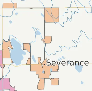
Severance (pop. ~10,000), through a series of strategic flagpole annexations and the three-mile rule, has a published planning area (which includes potential future annexations) that is a whopping 78+ square miles — far larger than the existing city of Fort Collins! It's a great example of how to carefully arrange current annexations to maximize the potential for future annexations under Colorado law.
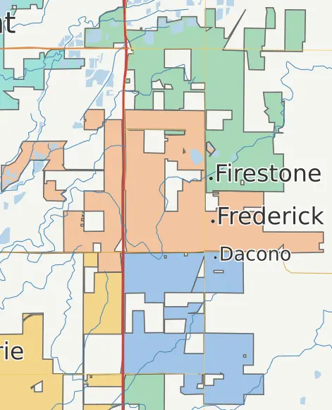
The original town sites of the three Carbon Valley towns (Firestone, Frederick, and Dacono) were very close to each other, which has led the towns to expand away from each other (north, west, and south, respectively), with the ensuing annexations naturally including plenty of land around I-25.
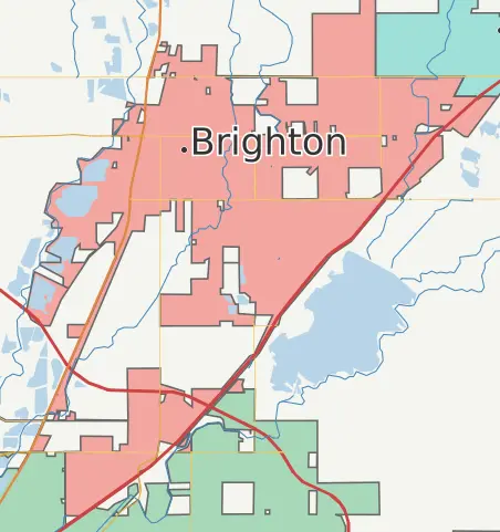
Even Brighton is looking to flagpole its way into some of that lucrative "inside the 470 loop, adjacent to highways" land. Similar to Erie's maneuver, they've managed to surround a large chunk of unannexed land to the south to keep Commerce City from getting all up in their business.
The shape of things to come
Most municipalities maintain a plan for how they will manage land acquired in potential future annexations, as required by C.R.S. §31-12-105(1)(e)(I) if they are interested in annexing. The planning areas defined by these plans provide an interesting glimpse into the future annexation ambitions of these municipalities. I was curious what the map would look like if instead of using municipal boundaries, I drew the municipalities according to their planning areas. I gathered planning area boundaries[5] for most of the municipalities in the I-25 and US-85 corridors, and used them to render the below map.
This map shows planning areas (as opposed to current political boundaries) for many municipalities in the I-25 and US-85 corridors. Areas in grey indicate land where the planning area boundaries overlap (and where future municipal battles will be fought?).
This map is, of course, complete fiction. Towns are pressured into drafting broad planning areas within the Colorado three-mile rule to keep their options open. It's no real indication that these areas will ever be incorporated or developed. Still, one wonders if the continuous stream of cities depicted here could be part of some future "Chey-buquerque" megalopolis.
Footnotes
- I know you can actually see municipal boundaries on Google Maps, one city at a time, if you select the city. I don't think this is a very satisfactory experience, since it doesn't work at all zoom levels, and only seeing a single boundary at a time doesn't effectively visualize the interesting territorial maneuvers that may be playing out between cities.
- Understanding municipal territory may be becoming more of a practical matter, though. People like to use city names to refer to places. As cities grow and city limits become more convoluted, it becomes harder for people to refer to places without confusion. If I'm shopping in Orchard Town Center and tell someone I'm in Westminster, I may need to clarify that with "No, not the Westminster that's along the Boulder Turnpike... the other Westminster."
- I don't mean to imply that the individuals running the towns are necessarily conniving. But every organization exists in an economic context with financial pressure, and people under pressure tend to follow incentives. Incentives can produce very positive results in many organizations, since people are usually incentivized to cooperate, negotiate, compromise, and reach arrangements of mutual profit. Incentives can be problematic, though, when there is a power imbalance. Municipalities have the power of government and the authority to levy taxes — a powerful capability that they have every incentive to leverage via annexation.
- While municipalities will often make a good show of negotiating land use agreements with nearby municipalities in an effort to achieve harmony, the moment such agreements become inconvenient they may be withdrawn and disputes handled in lengthy court battles instead.
- Many of these planning area boundaries were available for download from the various municipal GIS systems. To handle the ones that were only available in PDF documents, I traced them using the excellent geojson.io tool.
posted at 2026-03-28 10:20:43 MDT
by David Simmons
tags: gis maps colorado
permalink
comments